|
ENRC Submission | Created: 16/7/2011 | Last update:
11:47 2/08/11
E-mail: rolyroper@yahoo.com
|
.jpg "Cushing Ave 4/9/2010")
Causes and Remedies
or
“100 into 50 won't go”
by Roly Roper
A submission to the Environment and Natural Resources Committee of the Parliament of Victoria with respect to the flood events in the town of Creswick over the spring and summer of 2010/11.
This submission is mainly concerned with Term of Reference (c) waterways management, and to a lesser extent (e) local knowledge.
|
Contents:
Executive Summary, Author, Background, Scope, The Moore St channel, Nuggety Gully Creek and the Sludge Channel, Upstream Retardation, Below Clunes Rd, Calembeen Park, Community input, Hepburn Shire Council, North Central Catchment Management Authority, VicRoads, Conclusion The “Home” key will return to top |
* The Castlemaine and Clunes Rd bridges need to be replaced with clearspan bridges or floodways.
* Creswick Creek bed needs to be dredged deeper from Water St to the railway.
* Sawpit Gully Creek requires induction works at Creswick Creek.
* Nuggety Gully Creek needs a diversion to the West.
* Flow retardation works are required upstream.
* The NCCMA needs an almighty rocket.
The author is a retired Electronics Design Technician and Programmer with a wide range of experience in the design of industrial control and safety equipment, and biomedical and environmental monitoring.
Relevant experience includes instrumentation consulting to the establishment of the Latrobe University Ecological Reserve with the object of flood mitigation to the campus; consultation to the Digital Equipment Corp (DEC) for The Computer Aided Disaster Management System (CADMAS) following the Ash Wednesday fires; and radio net controller with the Wireless Institute Civil Emergency Network (WICEN).
Previous submissions include the investigation and reporting on various industrial accidents to the Department of Labor and Industry (DLI Vic), and to the Coode Island Review Panel (CIRP) on the cause of the fire at Terminals Ltd, Coode Island.
I own a house on Creswick Creek at Northcott Park and have been a Creswick resident for about three years. I have previously lived in the Manning Valley NSW and witnessed a number of major flood events there. My interests include fluid flow dynamics, the causes of disasters in man-made systems in general and air crash investigation in particular.
Unless otherwise noted all photographs are by the author.
Prior to these events Creswick Creek had been dry with only occasional flows for about a decade during the extended drought. While most of the water bodies in the region had dried out (Lake Wendouree in Ballarat actually had a grassfire), St Georges Lake above Creswick had only fallen to about two metres below the spillway. As a result those flows that did occur through the town were very minor and came entirely from Slaty Creek (which enters Creswick Ck at Northcott Park) and local runoff, but most of the time Creswick Ck was bone dry.
I was in Creswick and closely observed the flood events on Thursday 12/8/2010, Saturday 4/9/2010, Thursday 13 and Friday 14/1/2011, and the night flood over Friday 4 and Saturday 5/2/2011.
The first flow of any significance occured on 12/8/2010 and was in the form of a freshet that filled the creek but only slightly exceeded its banks between Northcott Park and the Water St bridge, causing no damage.
.jpg "Freshet at Northcott Park 12/8/2010")
Freshet at Northcott Park 12/8/2010 10:01
Note: many images also have roll-over captionsThe main effect of this event was to fill St Georges Lake up to the level of the minor spillway, and saturate the creekline. In so doing it effectively took up all the slack in the system, leaving no buffering capacity, and setting the stage for what was to come. This event is not further considered here.
It must be recognised that the January event was truly extraordinary and that even under the best possible conditions some flooding would have been unavoidable. That said, I hope to demonstrate here that the lesser floods were avoidable, and similar flood events can be avoided in future.
The interim report on the Queensland floods has just been released and no doubt contains many findings that will be helpful to the Victorian situation, but there are a couple of points that are worth highlighting here.
Some flooding of property situated on flood plains cannot be entirely prevented, but some measures can be taken that will help to minimise the impact of that flooding.
In particular public awareness of flood risk and response needs to be raised to a similar level to bushfire awareness.
A better system of warnings such as regular sounding of town fire sirens, together with public education as to how to respond correctly to those warnings, is required. Many vehicles, for example, were swamped that could easily have been moved to safety, and damage within homes and businesses could have been reduced.
It seems at the moment the only remote gauging station that exists in the catchment above Creswick is at Cosgrave Reservoir, and that this comprises only 25% of the total Creswick Creek catchment; so the basic information for warning simply doesn't exist.
In my own case I have lived with rapid flooding on the NSW Mid-North coast and prepared my shed, avoiding any loss when it flooded, and moved my vehicle to higher ground; yet far too many people were taken totally by surprise even by the later floods and claimed that they “had no warning”.
In reality they failed to heed the warnings that were given by the BoM for the Loddon River because they didn't realise that they were living, firstly, on a flood plain, and secondly, in the headwaters of the Loddon.
My observations ranged from Cosgrave Reservior upstream of the town to the Ring Rd floodway downstream, but particularly through the town from St Georges Lake to the railway crossing.

Creek flows are from bottom to top
(Sawpit Gully and Nuggety Gully Creeks not shown)Over that span the creek line has been very considerably altered from its historic course through the town, initially as a result of extensive alluvial gold mining works in the 1800's.
The historic course of the creek originally meandered considerably over the span but it was aligned by stages into its current course which is effectively fully-aligned straight sections.
The most significant alignment occured in 1862 when the section between Water St and Castlemaine Rd was turned into a channel roughly parallel to the lower part of Albert St. This channel is now bounded on the East side by Moore St and is therefore here refered to as the Moore St channel. At the bottom end of this section Sawpit Gully Creek joins Creswick Creek (ref: G8, H8, I8 above).

The Nuggety Gully Creek/“Sludge Channel” is at leftIt is this Moore St section that is the primary source of Creswick flooding.
The lower section below the Clunes Rd crossing was aligned at some later date but is significant because this contained an anabranch enclosing what may have originally been a swamp or billabong where the historic course of Nuggety Gully Creek joined Creswick Ck.
At some time Nuggety Gully Ck was also aligned and relocated well to the West of its historic course in what is now called the “Sludge Channel” from its original role in upstream gold mining works. This channel is bounded on its West side by Drummond St (ref: E9, E10 above).
This Sludge Channel is the secondary source of Creswick flooding.
This section is a major narrowing of available flow area, but despite this the channel itself demonstrated a flow capacity without overflow during these events of around 80 cumecs (cubic metres per second) even in an overgrown state.
The entrance to this section is the Water St bridge which demonstrated a flow capacity of about 100 cumecs.
.jpg "Water St bridge inflow at full capacity - January")
Water St bridge inflow at full capacity 14/1/2011 10:14While this bridge is just coping with this capacity inflow, large areas downstream are already well flooded at this time.
The exit from the Moore St section is a culvert bridge at Castlemaine Rd which demonstrated a best case flow capacity of around 50 cumecs. Calculations based on data from culvert manufacturers produce a maximum flow capacity for this bridge of 49 cumecs, in close agreement with my 50 cumec estimate based on cross section measurements and velocity estimation. This close agreement is a verification of my flow estimation methodology.
-c.jpg "Inflow already at the top of the culverts before the flood peak")
Castlemain Rd bridge inflow already at capacity 13/1/2011 15:44
.jpg "Showing a fall of about 20-30cm between inflow and outflow across the bridge")
Castlemain Rd bridge outflow already at capacity 13/1/2011 15:38
Fall between in and outflows due to bridge resistanceIt should be carefully noted that the flow shown above was already at the capacity of the bridges and well before the flood peak. A this time the flow was still contained in the Moore St channel, and the surrounds had yet to flood.

Castlemaine Rd bridge over capacity 9/4/2010 01:51 (pic: Kylie&Neville)
Flooding and major flow over Albert St at this time (background)

Albert St overflow 9/4/2010 01:52 (pic: Kylie&Neville)The elevated road surfaces of Albert St and Castlemaine Rd form an effective dam around this precinct, encompassing the businesses and dwellings on the East side of Albert St, the businesses and dwellings on the South side of Castlemaine Rd, and the Semmens Village retirement dwellings on the East side of Creswick Ck. This is also the area where the alignment of Sawpit Gully Ck joins Creswick Ck from the east.

The Castlemaine Rd “dam” - 4/8/2010 13:42 (main creek flow l to r, overflow over Albert St)
Albert St top, Castlemaine Rd & bridge right, Hammon Village left, Sawpit Gully Ck enters lower leftThe flow events of Saturday 4/9/2010, "the September flood", Thursday 13th and Friday 14/1/2011, "the January flood", and the night flood over Friday 4th and Saturday 5/2/2011, "the February flood", all exceeded the flow capacity of the Castlemaine Rd bridge, causing the water to pool back up the Moore St channel and take an alternative path across lower Albert St, resulting in flooding of properties on both sides of lower Albert St and Cambridge St behind, and major inundation of Cushing Ave.
The cause of this diversion was incorrectly identified by many as being only due to growth in the creek channel. While this growth certainly retarded flow velocity to some extent the popular claim that it was responsible for pushing the water out of the channel is not supported by my observations.
Hepburn Councilor Bill McClenaghan, ABC radio, 10 September 2010 9:47AM AEST
Play the interview (MP3, 2 mins)Most of what Cr McClenaghan says is valid, and his warning of more flooding was particularly prescient, however he failed to account for the floors (or inverts) of the bridge culverts which are at the current level of the creek bed, and that the bridges formed the primary and dominant obstruction to flow.
Photographs of Albert St and down Moore St clearly show that the creek flow pooled back from the restriction at the Castlemaine Rd bridge, and remained in the channel until arriving at the head of this pool.
As this pool filled it first overflowed the creek banks starting at the lower Castlemaine Rd end, progressively flooding properties back along Albert St to the West, and Semmens Village and Castlemaine Rd properties to the East.
Had the growth in the Moore St channel been dominant this flooding would have commenced at the top end, flowing across the IGA site and flooding the Bowls Club first, but as these photographs clearly show, that isn't what happened.
.jpg "Albert St pool, not yet overflowing 4/9/2010 09:57")
Albert St pooling back from the Castlemaine Rd bridge 4/9/2010 09:57
Note that at this time there is still no inflow to top of this pool (left).
.jpg "Moore St 4/9/2010 10:21")
Moore St pooling back from the Castlemaine Rd bridge 4/9/2010 10:21The photos clearly show water pooling back from the bridge before it was flowing over Albert St, illustrating that “growth pushing water out of the creek” is not correct; this pool is because water is unable to escape under the Castlemaine Rd bridge.
As each flood event progressed this pool grew back along the Moore St channel to the Water St bridge and diverted East into the Melbourne University Forestry School, and West through the CFA, IGA site, and Creswick Bowls Club on to Albert St.
What is clear from these observations is that the lack of flow capacity of the Castlemaine Rd bridge was the primary cause of the flooding along Moore St and Albert St, and significantly contributed to the flooding of properties in Cambridge St and Cushing Ave when Albert St finally started overflowing.
The identical Clunes Rd bridge just downstream of the Castlemaine Rd bridge was the primary cause of flooding in North Pde. These two bridges are identical in construction and in close proximity, and unless otherwise stated remarks about the Castlemaine Rd bridge are intended to apply also to the Clunes Rd bridge.

North Pde, between the bridges (4)/9/2010 (10:01) (pic: Laurie McBride)A historic creeklet joins Creswick Ck at this point with its historic line down Bridge St, crossing North Pde. Considerable local runoff from the steep hill catchment above caused this creeklet to reappear and contribute significant flow into the North Pde area above the Clunes Rd bridge.
Apart from a basic lack of cross-sectional flow area, the nature of culvert bridges contributed to the obstruction problem. By their nature culvert bridges have several vertical supports distributed across the flow, and these formed catch points for debris being carried down by the flow. This debris then lodged against the upstream side of the bridges, further obstructing the flow.
Apart from natural material such as twigs and branches of all sizes, man-made items included a ladder, a long bench, 44 gal drum, rounds of firewood, and a large number of plastic items such as milk and detergent containers.
-04092010-525x700-lmcb.jpg "Debris adds flow resistance - see rollover, above")
Castlemaine Rd bridge rubbish (4)/9/2010 (01:11) (pic: Laurie McBride)The Water St bridge with only two sets of round upright supports, and the clearspan footbridge at Victoria St, half way down the Moore St channel, were free of this problem. The material shown above had to clear these bridges to get to where it lodged.
The retarding effect of this debris was highlighted by one Albert St shopkeeper who remarked to me that when a claw was used to remove the debris the effect was “like pulling the plug out of a bath”. This again illustrates the adverse effect of the lack of design capacity, and the unsuitability of culvert-type bridges in these locations.
The clearspan footbridge in particular provides a good indication of the type of bridge, clearspan, that would work at Castlemaine and Clunes Roads.
A similar situation exists on a smaller scale along the Sludge Channel. The opening at the top of this channel where it crosses under Raglan St is considerably larger than the opening where it crosses under Victoria St.
In fact the Victoria St crossing, a large and impressive bluestone structure, resembles the Hoover dam. During the events this obstruction caused water to pool and back up the channel until it overflowed the bank into the Creswick Primary School.
-rh.jpg)
The “Hoover Dam”, Sludge Channel at Victoria StFrom there it followed it historic course across the school grounds, exiting at the intersection of Victoria and Napier streets, thence down the South side of Victoria St to the intersection with Cambridge St.
While there is still some doubt about how, there is little doubt that the flow then split, part flowing down an old brick-lined drain to join Creswick Ck at Victoria St (the Bowls Club), and part somehow crossing Victoria St to flow down its historic course in Cambridge St, most likely via backflow through underground drains.
-hp.jpg)
Victoria St drain entering Creswick Ck behind the Bowls ClubAgain, the primary cause of flooding of properties in Victoria St was the flow restriction of the Sludge Channel at the Victoria St crossing, significantly contributing to the flooding of properties in Cambridge St and Cushing Ave, and to a lesser extent the Moore St precinct.
It should be noted, however, that this flow restriction at Victoria St almost certainly saved the John Curtin Hospital downstream from flooding during these events. Simply opening this restriction is therefore not a realistic option and the flow needs to be redirected from above this point to the back of Calembeen Park. This would be a major undertaking.
An alternative worth examining would be to provide an overflow pathway from higher upstream to the West side of the railway line. This would have the benefit of reducing the flow loading at Calembeen Park and upstream of the railway bridge over Creswick Creek.
On both Creswick Creek and Nuggety Gully Creek there seems to be considerable opportunity for retardings works such as leaky weirs to retard flows into the town.
While these would be no magic fix they could certainly assist in moderating the flow to a volume that the channels could better cope with.
In the case of Creswick Creek it seems that the major part of the catchment is on Slaty Creek, and to be effective retarding works would need to be carried back up this arm.
These could have a side benefit of creating ephemeral wetlands, and could create a tourist attraction if done properly.
I understand that there is a proposal to lift the bridge on Old Melbourne Rd over Slaty Creek so that a walking trail can pass under the bridge for a safer road crossing.
While this is a good idea in itself, it would also increase the flow capacity of this crossing, and without matching retarding works upstream on Slaty Creek it would increase the inflow capacity to the town section, which is not a good idea. At the moment the combination of the bridge choke and the wide flat area above forms a natural retarding basin that needs to be enhanced, not reduced.
As St Georges Lake has fixed spillways consideration should be given to a syphon that would allow the level of the lake to be drawn down when required to provide some buffering against high flows.
The primary problem downstream of the Clunes Rd bridge seems to be simply that the bed of the creek is too high with respect to the surrounding area, in particular Cushing Ave.
After some dispute with Hepburn Council engineers over my eyeball estimate of the fall being only “a couple of feet” (i.e. about 600mm) after the establishment of a new open drain between Cushing Ave and Creswick Creek, quickly dubbed the “Lap Pool” for its lack of fall, it was conceded that the height difference is “500 to 700 mm” - or about two feet! I must remark that a laser level that has an error of +/-100mm over 100m requires repair.
-800x600c.jpg "Lacking fall it fills up, hence the nickname")
The “Lap Pool” from the creek to Cushing Ave, Cambridge St in the distance.
The Sludge Channel enters at right.The owner of A.A.Rods which backs onto this junction showed me where the water level had got to in his back shed during at least two flood events (the water mark still obvious), a level about two metres above the creek bed (about eye-level in the photograph above; see also reverse view below).
Even allowing that the height difference is a full 0.7 metre this still puts the creek level 1.3 metres above Cushing Ave (where most of the dwellings are slab-on-ground). While it is contended that this drain is only for “normal” drainage, it is apprently still disputed that it will facilitate flooding of Cushing Ave and surrounds whenever the creek level exceeds 0.7 mm.
It should be obvious that the bed of the creek requires lowering by a minimum of 1 meter at the very least, and better more like 2 metres. The NCCMA objected that this would increase the “energy gradiant” of the creek, which it will, but have remained silent when I repeatedly asked if they had a better idea.
I have since learned (unofficially) that there is now an intention to lower the creek bed by 2 metres for a distance of 1300 metres downstream of the Clunes Rd bridge. I am at a loss to understand why good developments such as this are being treated as if they are State Secrets - why not shout it from the rooftops? It would be very welcome news (if true).
As I feel that this comes under the heading of “the bleedin' obvious” since February, I have still not been given any reason at all for the continuing delay in carrying out these works. A cynic might suggest that the NCCMA have decided that the residents of Cushing Ave and Cambridge St simply have to tolerate more flooding.
-800x600.jpg)
Looking upstream to the Clunes Rd bridge.
The Motel can be seen far right.The next photograph graphically illustrates the problem.
.jpg "No flow yet over Albert St at this time")
Reverse view from Cambridge St toward the creek 13/1/2011 15:18
Car on Cushing Ave, Motel far rightThe water in the foreground is flowing down Cambridge St and across Cushing Ave away from the camera. It was this seemingly excessive runoff that led to the discovery of the overflow of the Sludge Channel into the primary school, and that its historical course had been roughly down Cambridge St. It should be stressed that at this early stage there was no flow across Albert St into this area at the time.
The water in the background is mainly backflow from the creek into the historic billabong area the “Lap Pool” now crosses, with some contribution from the join of the Sludge Channel, the portion making it through the Victoria St “Hoover dam” obstruction.
Calembeen Park is another entirely man-made area, created from the remains of a gold mining operation.
It consists of four connected lakes, bounded on the North side by the Creswick Creek, and on the West by a large embankment that carries the railway line.
The ground also rises sharply to the South, but to the East it adjoins the flat area that was the historic billabong between Cushing Ave and the creek, the location of the new “Lap Pool” drain discussed above.
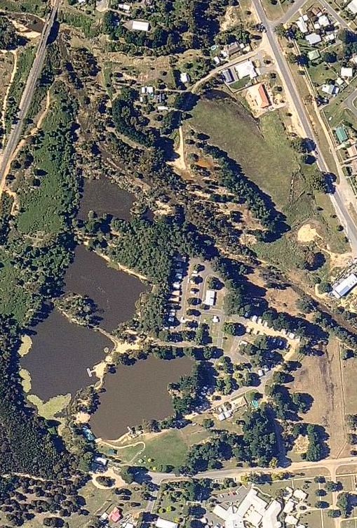
Calembeen Park SatMap 20/1/2011 (source: NearMap)
Rail bridge top left, Clunes Rd top right,
Caravan Park centre, billabong lower right,
John Curtin Hospital on Cushing Ave bottom right,
Sludge Channel enters bottom centreAs a result a considerable proportion of the flood waters escaped via Calembeen Park, first flowing Westward from the old billabong area into the top (South-West) lake, then North via the other lakes and a small wetland, then back into the creekline to exit the area under the railway bridge.
Unlike most caravan parks, most of this one is significantly elevated and was not as seriously impacted as other areas.
-800x600.jpg "Debris flattens fence in front of white car")
Calembeen Park inflow (r to l) from “Lap Pool” billabong 14/1/2011 09:28
South of Caravan Park (hidden in background trees)
Firewood rounds mark flowDuring the floods this entire path formed one continuous body of water from the “Lap Pool” billabong to the creek, leaving the elevated Creswick Caravan park as an island, the creek proper flowing past its North and the Calembeen overflow passing to its South.
Given that this path formed a significant escape route for water during the floods, a very strange decision was taken during the construction of the “Lap Pool” to reinforce the discharge of the Sludge Channel where it enters this area (it actually meets the creek at the same point as the Lap Pool drain).
-800x600.jpg)
Sludge Channel directed East, upstream, to “Lap Pool” billabong
Channel flow towards camera, flood flow away into Calembeen in backgroundAs the above photo illustrates, the flow from the Sludge Channel is being directed upstream of the caravan park, and against the flow of floodwaters. It would seem to be logical and simple to redirect the Sludge Channel flow into Calembeen park to reduce the pressure on the already overloaded Cushing Ave/billabong area, and that reinforcing the bund shown above makes it even more difficult for floodwaters to escape from the “Lap Pool” billabong and Cushing Ave/Cambridge St area.
The culvert under the road (just out of view right, above) was also tripled in size during these works, aiding the Sludge Channel flow into the billabong area. During each flood this culvert was entirely submerged and the flow going in the opposite direction. Triplicating this culvert fixes a problem that doesn't exist, and doesn't address the problem that does.
Somebody made a cynical decision that protecting the caravan park office was more important than the Motel and residents of Cushing Ave and Cambridge St when the latter were already much more seriously impacted. The office could still be protected by a bund that allows an escape path from the billabong area, but the reasoning behind this cheap, lazy, and indeed stupid “fix” is a mystery. Even a microscopic amount of thought would have produce the idea that redirecting the Sludge Channel to the West, downstream, would have had several benefits.
I have no idea who is responsible for this fiasco, HSC or NCCMA, but it seems to be a perfect illustration of the old saying that “a camel is a horse put together by a committee” - a flood “fix” that will make the next flood worse.
On the 18/1/2011 I wrote a letter to the Ballarat Courier cautioning that without due care there was a real danger of exactly this sort wasteful mistake.
Sometimes during my investigations of these floods I have wondered if the “responsible authorities” actually know that water flows downhill (and if that sounds unfair or unreasonable, take another look at the photo above). The redirection of Nuggety Gully Ck overflow upstream was accidental - this isn't.
There is also an unnamed creeklet that flows from the end of Lewers St which has been directed to the Sludge Channel when it could more easily have been directed into the second Calembeen lake. This illustrates an overall trend to direct side-streams, accidentally or deliberately, upstream into Creswick creek which can only add to the problems.
-800x600.jpg "Four lakes become one")
Calembeen Park 4/9/2010 14:16
Flow right to left, then away from cameraDownstream of the caravan park all the buildings are on the North side of the creek and were above the flood levels, in any case the creek is much less confined and able to expand until it comes to the join of the King St/Little King St creeklet and the significant choke formed by the railway bridge. It is also here that the Calembeen Park flow rejoins the creek.
-800x600.jpg "31/7/2011")
Downstream of the caravan park
Note clearing debris and scree forming bund, left
Railway bridge background rightThe clearing operation in February left a bund between Calembeen Park and the creek, possibly due to the difficulty of getting truck access to this area.
This bund is a mixed blessing in that it protects the wetland just behind it, but it also forms a significant obstruction to flood flows leaving Calembeen Park.
This area needs better management in the form of a spillway to retain the wetland but allow easy escape for floodwaters.
-800x600.jpg "31/7/2011")
Railway bridge upstream
King St creeklet enters left, Calembeen overflow enters right
Railway embankment far right
Much has been made of Community Consultation. The prefix con- is generally taken to mean “with”, but it also has the meaning “against”, and my experience of this consultation process has been more like the latter than the former.
E-mails on this matter to my local Councillors, to my local MLA, to the responsible State Minister, and even the Prime Minister, are all still awaiting reply after several months. Only the Premier has been good enough to actually respond.
While I can't speak for anybody else, I found the Hepburn Council in the form of the local Flood Office, and the NCCMA receptive to my input.
I've now done several walk-arounds of the creeks with interested people, the first two with people from the Flood Office, and from NCCMA and their consultants. I found them interested and receptive, eager to get CD-R's with my 250+ photographs of the flood events.
I would like to say I have worked in co-operation with them, but overall it has been mainly a one-way street, particularly compared to other interested parties who have been very forthcoming in sharing information.
While the Flood Office has kept me informed of developments the NCCMA has been a black hole - it all goes in, and nothing escapes. After the best part of a year of e-mail exchanges I am left with a strong impression the NCCMA has something to hide.
While the Flood Office has been as forthcoming as possible, when it comes to action they plead that they can't actually do anything to the creek without the permission of the NCCMA, and for the most part that has not been forthcoming.
The failure to even clear the creek until after the last flood is still a sore point in this community - too little, too late.
As for the Council itself, I have repeatedly requested any information that it can provide about the drains in the Victoria St Cambridge St area so I can proceed to investigate and hopefully resolve the question of how the Sludge Channel overflow is finding its way to the top end of Cambridge St.
To date I am still waiting for this minimal support to lend my assistance to this process. My understanding is that it is the Council Engineering office that is being unresponsive.
My impression is that nobody from this office actually bothered themselves to inspect any of the flood events on the ground when they were happening and the most was to be learned. Photographs are a poor substitute for witnessing at first hand.
A meeting was held specifically to deal with mental trauma caused by these flood events, but was so poorly advertised that it was attended, I am told, by just three people. I hope it was the right three people because I personally witnessed one person suffering an emotional melt-down during the night flood.
I'll be right up front; my current impression of the North Central Catchment Management Authority (NCCMA) is of an organisation that has utterly lost the plot, that sees “catchment management” as some sort of abstract exercise quite unrelated to any form of management in reality, divorced from why it exists in the first place and who for - that is to manage the catchment in the interests and wellbeing of the people who live here - and has demonstrated no sense of urgency to prevent more flooding.
Process has become an end in itself rather than a means to the end of flood reduction. Attachment to process has actually increased the risk of more flooding in Creswick by delaying effective action.
A mature tree growing upstream across two of the Clunes Rd bridge culverts, and up to a metre of scree accumulated in them, isn't “management”, it's “negligence”.
-800x600.jpg "Utterly shameful neglect of duty")
Clunes Rd bridge with mature tree growing across two culverts 6/2/2011
A monument to neglect
-800x600p.jpg "Scree is not the only obstruction")
Castlemain Rd bridge with up to a metre of scree 8/2/2011Despite repeated calls to clear the creek and bridges of obstructions following the September 2010 flood the creek was not cleared until February 2011, after the last flood, and the critical scree accumulation in the bridges, like that shown above, some time after the general clearing of channel growth.
The failure to heed calls from Councilors and residents and act promptly to remove such obvious flow obstructions after the first flood made the impact of the following floods worse. In my view this inaction amounts to gross negligence and an abdication of NCCMA duty of care that borders on the criminal.
Last September the NCCMA was overtaken and sidelined by events, and it not only hasn't caught up, it hasn't yet woken up.
The NCCMA stopped actually managing the Creswick creek, so far as I can tell, over a decade ago, and nobody noticed until last September.
Now people have noticed; the NCCMA has been given an opportunity to step up to the plate and redeem itself, and failed miserably - it is still AWOL and left a management vacuume. Creswick Creek must be managed, so the vacuume must now be filled by an entity that can and will do the job.
The culvert bridges must be removed and the creek bed lowered by dredging progressively downstream from Water St, this much has been obvious since at least February; yet we will arrive back at September, a full twelve months, with nothing to show but a hyrdology report to mop up the next flood water.
Emergency services, the CFA, and SES are now being restructured following the Black Saturday debacle where the CFA “lost” the Kilmore fire with such tragic outcome, despite the precursor when they “lost” the Trentham fire on Ash Wednesday.
Similarly, there is a real risk of another flood event or events this coming spring/summer, and if so the NCCMA will be directly responsible by their inaction.
The NCCMA is overdue for a total clean out with a Rota-Rooter.
I have not had any communications at all with anybody from VicRoads, but I am now given to understand that the problem with the bridges is recognised and being acted on. Given that I was apparently the first person to identify this problem, and have been continually pushing in public and private to have something done about it, it is disappointing that nobody from VicRoads has contacted me for a walk-around and exchange of views. I still live in hope.
The responsibility of VicRoads is clear; these bridges do not meet minimum standards and were therefore improperly designed.
“General Freeboard Requirements
Freeboard is the height above a defined flood level, typically used to provide a factor of safety in, for example, the setting of floor levels and levee crest levels (i.e. design flood event). Freeboard compensates for effects such as wave action, localised hydraulic behaviour settlement of levees and sedimentation in waterways, which increase flood levels or reduce the level of protection provided by levees. Freeboard also provides protection from floods that are marginally above the defined flood level. However, freeboard should not be relied upon to provide protection for flood events larger than the defined flood event.{Source: Floodplain Management In Australia, Best Practice Principles and Guidelines, SCARM Report 73, CSIRO Publishing, 2000).
Freeboard is required to set minimum fill and/or floor levels in new developments that are in the vicinity of overland flowpaths, open waterways (river, creek, channel) and floodplains.”
Given that these bridges were constructed close to existing buildings the floors or inverts were simply set too high to meet a reasonable freeboard requirement, particularly considering “localised hydraulic behaviour” and “sedimentation in waterways”.
“Bridge Design Considerations
A clearance of 600 millimetres between the one in 100 year peak flood level and the underside of the bridge is required for road crossings.”
(ref: Melbourne Water Land Development Manual, 5.3.2 Designing for Stormwater Conveyance - Hydrologic and hydraulic design - external link, requires Internet access)These bridges clearly do not meet these requirements, particularly considering the proximity of nearby buildings level with the current bridge underside.
Even setting aside the very extreme January event, they still failed to cope with the other lesser floods.
Historically there is a very real chance we will now get several wet years, particularly following such a strong La Niña event, that will again produce flows in excess of the current capacity of the creek, and particularly the Castlemaine and Clunes Rd bridges, resulting in more flooding.
At the time of writing NSW is experiencing above average rainfall and there is flooding in Gippsland. This does not augur well for the coming spring and summer.
The need for urgent action on deepening the creek and opening the bridges was obvious after the first flood in September, but lead time has been frittered away, mainly by the NCCMA, and condemned the residents and businesses of Creswick to yet more flooding.
The neglect of the NCCMA in large part produced the current situation, and they seem to have little or no interest in correcting it.
