-c800.jpg "15:18 13/1/11 water flowing away from Cambridge St across Cushing Ave")
| http://www.ozvalveamps.org/temp/cushingave.html | Created: 30/01/11 | Last update: 02:03 7/04/11 |
Elsewhere we look at Creswick Creek proper, but during observations of the unfolding event on 13th of Jan '11 the state of Cushing Ave, Cambridge St, and the Drummond St “sludge channel” were also noted.
What was happening along the actual creekline was fairly obvious, but there was no obvious reason why the intersection of Cushing Ave and Cambridge St should be flooding at this stage of the event.
Where was this water coming from?
It was easy to see where this water wasn't coming from;
- it wasn't coming across Albert St because the creek was still in its channel at this time,
- it wasn't coming from the Drummond St “sludge channel” because it was also still in its channel above Cushing Ave,
- and it wasn't coming back up Cambridge St from the creek because it was clearly flowing the other way, towards the creek.
There are reports that at least some came from stormwater drains backing up. It has been assumed that these backup flows originated with the creek, and given that the intersection of Cushing Ave and Cambridge St is at the bottom of a significant depression (which may actually be below the full creek level at that point) it's a reasonable assumption.
But what I observed left me with a nagging doubt that this was the entire story. Unless Cushing Ave drains uphill back to the creek at Albert St; or water can flow magically back up a drain, out and back down to the creek, this initial flooding has to have come from somewhere above Cushing Ave, up Cambridge St.
Eventually a map turned up of the Creswick gold diggings from 1880. In this abstract the floodplains have been highlighted.
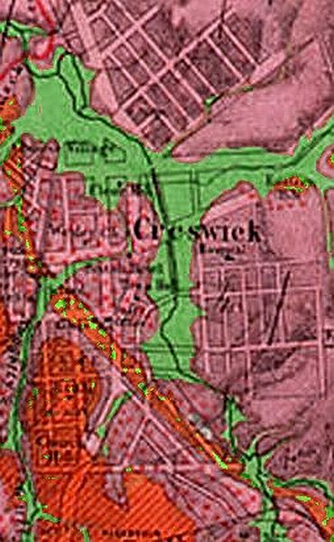
On close examination there were a few surprises. The sheer extent of the floodplain around the confluence of Creswick and Sawpit Gully creeks, from Hammon Park to Calembeen Park, is a bit of a shock when you look at how confined it is today.
There once were a large number of small or ephmeral creeklets that joined the creek through the town, and it is likely that most of these still join the creek, but now as stormwater runoff drains.
At bottom left we can see the initial line of Nuggety Creek that was to become what is charmingly called the “sludge channel” that runs past the School, along Drummond St and past Calembeen Park to the creek.
But as we follow the 1880 path of this creek something disturbing appears; it originally curved to the right across what is now the Primary school, generally down Victoria St, then turned left down Cambridge St.
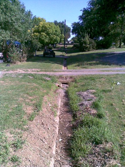
This view up the east side of Cambridge St shows the “gutter” which is actually the remains of the of the historic Nuggety creek line.
Just about every flow line in the town has been “managed” into straight drains, culverts, and lined channels. Within their flow capacity things are generally fine, but when their capacity is exceeded they revert to their historic lines.
This old creek line suggests that the origin of the initial flooding of Cambridge St and Cushing Ave isn't Creswick creek, but due to its own historic Nuggety creek coming down the hill behind, apparently assisted by the drainage system.
Update 7/4/11
On the 25th March I met with Rohan Hogan, Project Manager for the NCCMA Creswick Flood Mitigation Plan and their consultants for a walk-around inspection.
We concentrated on the “sludge channel” (the diversion of Nuggety Gully Creek along Drummond St) and its relationship to Cushing Ave and Cambridge St, had a very useful exchange of information, and together filled in some important missing pieces.
I had previously inspected the historic creekline down Victoria St from the school and confirmed from remaining flow marks that flood water had spilled out of the sludge channel into the historic line at the school, then down to the intersection of Victoria and Cambridge streets.
There is a very old brick drain that runs from the intersection of Victoria and Cambridge streets directly down Victoria street to meet Creswick creek just below the footbridge.
-hp.jpg)
It has yet to be proven, but it seems that this also has a connection across to the top of the hill in Cambridge street. With any significant flow in the Creswick creek this drain would have been subject to hydraulic damming at the bottom end, and in any case would have been solid with water by the time Albert St flooded.
It is not likely that that this lower section was flowing backwards, but it is almost certain that water coming down Victoria street would not have been able to escape in that direction and flowed backwards up the connecting arm under Victoria street to Cambridge street north where it re-emerged from the drain system to form a surface flow.
Given its small size, rough brick lining, and length, it is most likely that it would have been overwhelmed by the sheer quantity of water flowing from the school, whatever the situation at its Creswick creek end.
Examination of the “sludge channel” beside and below the school suggested that it was choked with growth and scree, but when we came to the where Victoria street crosses the sludge channel we all had a Eureka! moment.
This crossing is built out of bluestone and dates back to the 1800's. The channel level here is five metres below its surrounds, while the total culvert area available for flow is only around one square metre. In fact it looks more like a dam than a street crossing.
-rh.jpg)
Suddenly a number of things become clear, in particular why the channel flow was forced to divert via the school, Victoria and Cambridge streets, and why the lower section of the sludge channel didn't overflow into the hospital.
Similar to the lower road bridges over Creswick Creek, no amount of clearing or deepening of this “sludge channel” will make any difference at all unless this gross restriction under Victoria St is fixed.
The first difficulty is that this crossing is a heritage structure and may require a large culvert to bypass it altogether.
The second difficulty is that once bypassed to save Cambridge St it is most likely that the hospital will then flood instead, and that Cushing Ave, the caravan park and motel will go under even deeper.
Meantime the Council has just completed an open drain from the bottom of Cambridge St to the Creswick creek.
This drain is not only a purely cosmetic and ineffective waste of resources, it is actually lower than the creek flood level and will only make it easier for the Cushing Ave area to flood.
|
|