With acknowledgement to the Bureau of Meteorology
| http://www.ozvalveamps.org/temp/feb4th.html | Created: 5/2/11 | Last update: 11:38 8/02/11 |
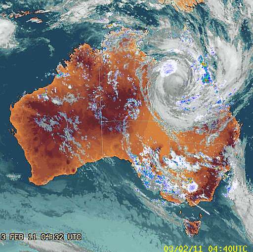
In the early hours of Feb 3rd Cyclone Yasi made landfall on the Queensland coast, one of the biggest and most powerful to strike Australia.
As it moved rapidly inland it fed a plume of hot moist air down into the south-east corner of the continent. This brought bands of intense rain to areas of Victoria and New South Wales that are still reeling from record flooding in January.
Creswick received about 50mm of rain in bursts from passing thunderstorms between 6pm and midnight, and another 50mm in a second band between midnight and 6am.
Around 9pm water was pooling and flowing over roads even in higher places such as Melbourne road. A large surface flow was observed coming down the top end of Albert St past the Commonwealth Bank, flowing in a sheet across Albert St at the rotunda. The gutter at Albert and Water streets was overflowing. All of this was local surface runoff.
.jpg "Upper Albert St drain overloaded with surface runoff")
St Georges Lake rapidly went up to a flow level over the big spillway similar to the January event, around 850mm, but this time the contribution of Slaty creek was much less, both lower and slower, perhaps around 10 cumecs (cubic metre per second), making a peak total infeed of about 80 cumecs past Northcott Park.
Despite this somewhat lower volume by midnight Northcott Park and Hammon Park were once again flooded, although to lower levels than in January. There was no flow over Water St this time so the Water St bridge capacity was not exceeded, supporting its capacity estimate of about 100 cumecs.
Flow velocity was observed at Water St and Castlemaine/Clunes Rd bridges and was clearly faster than in the January event, around 3m/s.
By 3am Cushing Ave and Cambridge St were again flooding, and both bridges were closed to traffic despite not overtopping and appearing to be just within capacity.
.jpg)
It is the headwater of the Castlemaine road bridge, water piling up against it unable to get through, that is causing all the heartache back from the bottom end of Albert St, and it's the same story with the Clunes Rd bridge and North Pde.
The event last night sits about midway between the September and January floods (80 v. 60 and 100 cumecs), yet the system handled more water with less flooding. When you are up to your knees it's hard to be thankful it isn't your neck, but things actually are getting better.
Each of these flood events has contributed to clearing the channels by scouring, reducing friction and increasing capacity by increasing velocity, but the material being removed, growth and scree, is also getting hung up on bridge culverts and blocking them.
This material has a blocking effect that is larger than its surface area would suggest because it also causes turbulence in the flow as it enters the culvert which also reduces its flow capacity.
The increased velocity is a mixed blessing. While it clears water faster erosion also rises sharply above 2m/s and the clubhouse at Hammon Park is now in danger of having its foundations undercut in future events. A large bite has been taken out of the creek bank by this last flood.
I've been observing creeks and floods for a long time, and with flood and erosion control the “no free lunch” rule applies. There tend to be winners and losers.
You can move floods around, up or down stream to where they don't matter, but floodwater is like a 500-pound gorilla - it will go where it damn well pleases, and it is pleased to take the path of lowest resistance which is generally its historic course. That is what Creswick has been witnessing. The town once had many little side creeks and creeklets that have been reasserting themselves.
The second rule is “you can't push a piece of string”, surface water has to be enticed, it can't be forced or driven.
Below Clunes Rd
Clearing should therefore be carried out from the bottom up. Here this means starting somewhere around the Ring Rd floodway or the railway bridge and working back to Clunes Rd.
This will help Cushing Ave, Calembeen Park and the motel, but it is unlikely on its own to fully cure the problems there, nor will it make any significant difference above Clunes Rd.
The two bridges
The lower bridges and the channel between them is a critical area that needs to be kept clear at all times until this choke is fixed.
At this point the hard-hit folk just above Castlemaine Rd will benefit, however North Pde may actually go a little deeper.
Stop Press: on 7/2/11 work was carried out between these bridges that removed the vegetation and other rubbish in the channel. This can be expected to have a very beneficial effect on flow in the predicted rain events for later this week.
There still remains about half a metre of scree in the creek bed and bridge culverts and this really needs to be pulled out to restore the creek bed to the grade line between the bridge bases.
Moore St channel
Clearing the Moore St channel between Castlemain Rd and Water St, of what, and how much, are more vexed questions.
Even fully cleared the bridges are still a major obstruction or choke. As we start to clear back above Castlemaine Rd we start to accelerate water towards this choke at the end.
It has now been very well demonstrated that this channel can carry more water without flooding than the bridges can pass. It's not flow resistance that is causing the creek to leave its channel, its the bridge and road forming an effective dam.
“You can't push a piece of string”. Clearing won't ram more water through the choke, it will only cause it to pile up against the resistance of the Castlemaine Rd “dam” as a headwater - and Albert St, Semmens Village, Cushing Ave and the motel go under again.
Until the bridges are fixed to allow a lot more flow to escape from this section, improving the flow above Castlemaine Rd will only make matters worse. This is a frustrating conclusion because even a “cheap” and “easy” solution like turning both into floodways is at least a year away, and clearspan bridges even more remote.
The channel was built in the two years after the 1860 flood. Is it too much to hope that in this age of computers, lasers, huge earth-movers and concrete we could do less, quicker?
Just as we have too much flow friction at the bridges, so it is possible to have too little friction in the channel and turn an inundation into a flash flood. Even at a modest one meter per second moving floodwaters can push on structures with the force of a bulldozer.
Some erosion or scouring is also a good thing because it keeps the creek and structures clear, requiring at least 1m/s, but this has to balanced with a sharp increase in erosion between 2 and 3m/s, so some friction to limit velocity to less than 3m/s is still needed.
Because the energy in the flow rises as the square of its velocity allowing floodwater to flow rapidly is a bit like handing a loaded gun to a gorilla, and it isn't hard to imagine a fast flowing flood re-establishing its old channel through Krackerjacks and the motel.
What to clear?
The mature trees along Moore St play no role in flow at all. The trees on the levee on the Albert St side also play no role in normal flow, but they bind the levee and provide a buffer for the properties against flow damage and any heavy objects being carried by the flood.
There is apparently official authorisation for the removal of any growth within the creek that has been flattened or damaged by the flows.
There have also been calls for deepening the channel. Again we need to be cautious and understand the limitations and possible bad effects before we act.
The most important scree to remove is in the bridge culverts themselves. The Clunes Rd bridge appears to have about half a metre of scree in the bottom, reducing its already limited flow capacity by about 20-25%.
When it comes time to dig out the channel base it needs to be clearly understood that making it deeper than anything downstream will only cause pooling where the bed has to rise up again. At the moment the bottom end is defined by the base level of the bridges, and the gradient of the bed must rise smoothly all the way back to Water St.
If this channel were “ideal” then it could carry 300 cumecs at 8m/s without flooding (but both bridges would be relocated to Clunes).
More realistically, fully cleared it has a maximum capacity of about 100 cumecs at 3m/s without flooding - the January event. But at best the bridge at the bottom can only cope with 60-70 cumecs, and we've got another flood.
So we come back to the bridges as the critical element. They simply weren't designed for this. This situation is made much worse by material piled up against, and blocking, the bridge culverts.
Until there are major changes to these bridges, keeping what flow capacity they do have full open is critical. This is at least as important as clearing fallen trees on roads because it has the secondary effect of closing several roads.
Above Water St
The more you clear back up the channel, the worse it gets lower down. This was the mistake Clunes made in clearing their Bowling club section.
Clearing above Water St bridge to increase flow would be simply insane, something akin to calling an air strike on your own position or sawing off the branch you are sitting on. The problem into Water St is that the 3m/s velocity is now too fast and causing serious erosion, and we want the inflow limited to no more than the channel and bridges can handle.
We have seen what happens when you pour 100 cumecs into the top of the channel and only let 60 cumecs out at the bottom.
This requires a lot more flow resistance so that inflow can flood back where it is harmless above the town, and release it slowly down through the town at a rate the rest of the creek can cope with.
Conclusions
At the moment the two lower bridges are the primary cause of the flooding problem, and keeping them clear for maximum flow at all times is the number one red-hot priority. Just clearing them of debris is by far the most profitable clearing to do. Only a little effort at this key point will give a disproportionate return. It won't prevent flooding, but it will minimise it.
Those culvert bridges are unsuitable for the service and have to go. Until they do, clearing is mainly limited to downstream, and won't have a lot effect anyway.
Some distributed clearing of the Moore St channel, say just the bed, could be carried out at this stage provided that there is a clear understanding, particularly by those at the bottom end, that reducing flow resistance above them without reducing flow resistance below them will actually make their situation worse; and that it will do nothing at all to prevent another flooding of lower Albert St.
|
|