-c.jpg "15:42 8G - S, from Castlemaine Rd, drain and sandbagging levee behind Albert St properties")
3:47pm
| http://www.ozvalveamps.org/temp/13-1-11-15-42.html | Created: 21/01/11 | Last update: 09:26 24/01/11 |
or Why Clearing Won't Help
Heavy rain overnight has brought up the level of Creswick Creek, and more rain is predicted. The creek is already flowing briskly as emergency volunteers frantically sandbag the levee behind Albert St properties above Castlemaine Rd. They have blocked the outlet drain (bottom left) to prevent backflow, and are pumping accumulated runoff from the drainage channel in the foreground - this is not yet creek overflow.
3:47pm
Meanwhile (below) water is already pooling at the foot of Cambridge St and flowing over Cushing Ave towards the creek (n.b. not from the creek). This is not yet coming over Albert St or from the Drummond St “sludge channel” (both of which are flowing at near capacity but still within their banks at this time), so it seems that this water is runoff from the hill behind.
-c800.jpg "15:18 8F - N, Cambridge St across Cushing Ave toward creek")
It should be stressed that this initial flooding appears to have nothing to do with the creek. The creek is not yet overflowing and the flow here is across Cushing Ave towards the creek, not backup. If the primary problem here is that the drainage is at or below the full creek level then no amount of creek clearing will make the water run uphill.
Clearing the Drummond St sludge channel will deliver water more rapidly into the lower pool in the background, lifting its level.
At this stage the creek can be seen (top) behind and is almost at full capacity, flowing swiftly, but still within its banks despite the vegetation in the channel. At this time the level is still about half a metre below the levee (and the outlet drain is still above creek level).
-c.jpg "8G - S, from Castlemaine Rd bridge, jury-rig drain block")
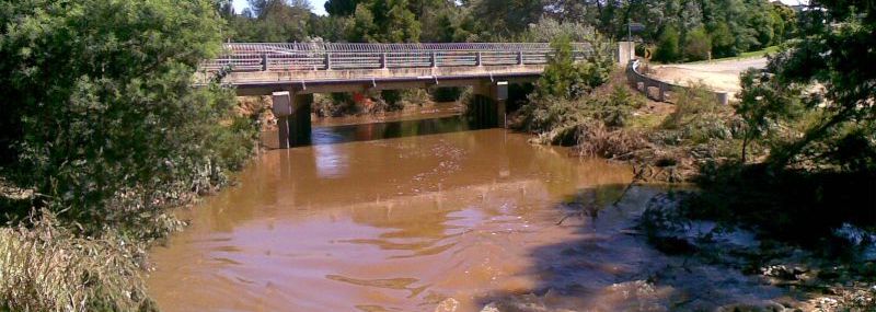
At the same time however the Castlemaine Rd bridge itself is already close to its maximum flow capacity with the inflow level only a few centimetres below the top of the culverts.
The channel is handling it, but the bridge is almost full.
-c.jpg "8G - S (upstream), Castlemaine Rd bridge inflow at capacity already")
3:44pm
-c.jpg "8G - E, downstream side of Castlemaine Rd bridge")
3:38pm
In contrast the discharge side level is around 20-30cm below the top. Presuming the bridge is level, this fall is mainly due to the flow resistance of the bridge.
The flow then turns left past North Pde, which was already suffering flooding (as is the intersection of Cushing Av and Cambridge St).
-c.jpg "15:33 8G - S.E. along North Pde (between bridges)")
Given the minimal growth and flow friction between the Castlemaine Rd and Clunes Rd bridges it is hard to see how it is causing this flooding, or more to the point that its removal would prevent it. The apparent cause is water backing up against the Clunes Rd bridge itself.
This poses a couple of questions about simple creekline clearing.
Anything that enhances flow also moves the flood protential downstream.
Just as clearing above Water St would admit more water to the Albert St section and make matters worse, so clearing the Albert St section must be expected to make matters worse at North Pde. The object of clearing is to make the water flow faster, so clearing will allow the delivery of more flow to the Castlemaine Rd/North Pde area - then what?
The flow area of the Castlemaine Rd bridge is 34 square metres, and with the channel full, and the bridge just full, the flow is around 30 cu.m/sec (~1m/s). Above this volume flooding starts to occur as water backs up against the bridge resistance because there isn't sufficient gradient to drive it faster. With a fully flooded head (i.e. water spilling over Albert St) its capacity seems to be around 60cu.m/sec (~2m/s).
If the bridges are the dominant flow restriction then removing lesser restrictions won't make much difference, and could even make things worse for some people.
Under the Clunes Rd bridge into a wide and straight channel past Calembeen Park.
.jpg "8G - NNW downstream from Clunes Rd bridge (Midland Hwy)")
Downstream of this bridge the flow is virtually unrestricted and already clearing the bridge at close to the best possible rate. Given the fall of the creekline it is difficult to see how any treatment such as clearing, widening, or deepening would significantly accelerate the water away downstream from this bridge.
It is obvious that the section above North Pde has more vegetation and is therefore more restricted than downstream - but North Pde was already flooded before the creek broke its banks above Castlemaine Rd. Proponents of simple “clearing” need to give this fact some serious thought before they rush in.
These observations suggest that;
- it is the flow resistance of these bridges that is the prime cause of Albert St flooding, and
- that the flow resistance of the channel from Water St is a minor factor (the channel limits at a greater flow than the bridge).
To test this idea we can look at how the flooding develops.
- If the bridge is the dominant cause then we would expect the flood to originate there, and spread back.
- If vegetation in the channel below Water St is the dominant cause then the flood should originate in or above that resistance, just under Water St.
In the first case a water pool would grow back along Albert St. In the second case water would initially flow across the Bowls club and IGA site, filling the pool from above.
-c.jpg)
It is clear that the pool is backing up from Castlemaine Rd and that there is no inflow at all at the top end.
In the 4/9/10 flood it was reported that the Castlemaine Rd bridge was obstructed by material (possibly that had washed down in the 12/8/10 freshet), and that when was removed “it was like pulling the plug out of a bath”[3].
The problem with the 14/1/11 event was that the mass of water was sufficient to overload the bridge capacity even when it was clear of debris.
-c.jpg "Moore St")
This image is particularly telling as it illustrates several points;
- water is pooling back from the (obstructed) lower end - water is unable to escape from this section
- despite the vegetation the flow does not leave the creekline until it gets to the head of the pool below
- Moore St has no flow friction, but
- even when the flow takes the Moore St path it still cannot escape
Damage to the far end of the fence on the right indicates a major flow to the right at that end.
It is only when the head of this pool reaches back to the Bowls club and IGA site that the flow takes that alternative route via Albert St, closer to its historic line.
At this point the properties in Albert and Moore Streets are sitting in a lake bounded by Albert St, Castlemaine Rd, and the Forestry School, with the creek flowing past front and back.
While the event of 12/08/2010 may have caused material to obstruct the bridges, the event of 04/09/2010 resulted in a noticable clearing of the creek line by flushing out, so on 13/1/2011 there were no apparent obstructions to capacity flow under the Castlemaine Rd or Clunes Rd bridges.
What was apparent was that even the un-obstructed flow capacity of these bridges is insufficient to clear the potential inflow at the Water St bridge.
What only became clear later was just how much they fell short.
-c.jpg "11G - N along Moore St from Water St; going around (right) and flow breaking to the right")
By this time a strong flow has established across Moore St into the Forestry School but even this is insufficient and the pool has continued to back up and establish a strong flow across the IGA site (far left) and along Albert St.
At this time the flow had already exceeded the capacity of the Water St bridge and was flowing around it across Hammon Oval and Water St (foreground above).
By any measure the 14/1/2011 event was extreme, part of a pattern of extreme flooding across the whole of eastern Australia.
The slug of water that hit Creswick flowed on down the Loddon (despite Tullaroop Reservoir) and Murray rivers as one of several flood heads causing mayhem as they passed through many towns and communities.
These floods are consistant with decades of climate predictions of more frequent extreme events, and it would therefore be prudent to assume that measures to accomodate them will be a wise long-term investment.
It has been calculated that a 20% increase in rainfall turns a 1 in 100 event into a 1 in 17 event.
-c.jpg "11G - W, Water St bridge at capacity")
|
|